2014/04/01
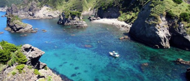
This shore of boundary of tree is the shore proud of outstanding transparency among national park, Cape Iro-zaki.
It is place where plain nature was left for by unique geographical environment that we can go only by ship.
This shore where way of the Kuroshio Current and various conditions such as it being were piled up near being covered at the tip of peninsula by sheer cliff and acting, and the whole area being national park, and any development not being done at there not being rivers, the southernmost shore of Izu Peninsula is beautiful beach of water most in Izu district.
Because water is beautiful, and seasonal migratory fish of southern country and migratory fish of big game turn around by the rich Kuroshio Current, it is perfect point for snorkeling.
In addition, precious Eda coral grows in colonies and is place that is full of sceneries registered as Izu Geopark.
Basic Information
| Name | The middle tree (key) shore |
|---|---|
| Address | Nakagi, Minamiizu-cho, Kamo-gun, Shizuoka |
| Closed | We are canceled, and day when wave is high is holiday |
| Open hours | 8:30~16:30 |
| Fees | hirizo beach handing over rate ・Adult 1,000 yen (more than junior high student) ・500 yen for children (4 years old or older to ~ primary schoolchild sixth grader) |
| Getting there | It is a 2-minute walk from bus stop “relation tree” by bus from Izukyu-Shimoda Station for 40 minutes |
| Parking lot | Available (1,000 yen paid in the summer) |
| Contact | Minamiizu TownTourist Association TEL: 0558-62-0141 |
| Website | http://www.nakagi.jp/hirizo/ |
※ This article was translated automatically using a machine translation system. Our editor is working on editing this article now. We will provide a fully updated version as soon as possible, please come back later.
※ Please make sure the info you see is the latest in advance.


